

Menu
Arrowhead Trail

Association
Name: Arrowhead Trails Association.
Organized: July 11, 1916.
Headquarters: Redlands, CA.
Arrowhead Trail cities and towns by State
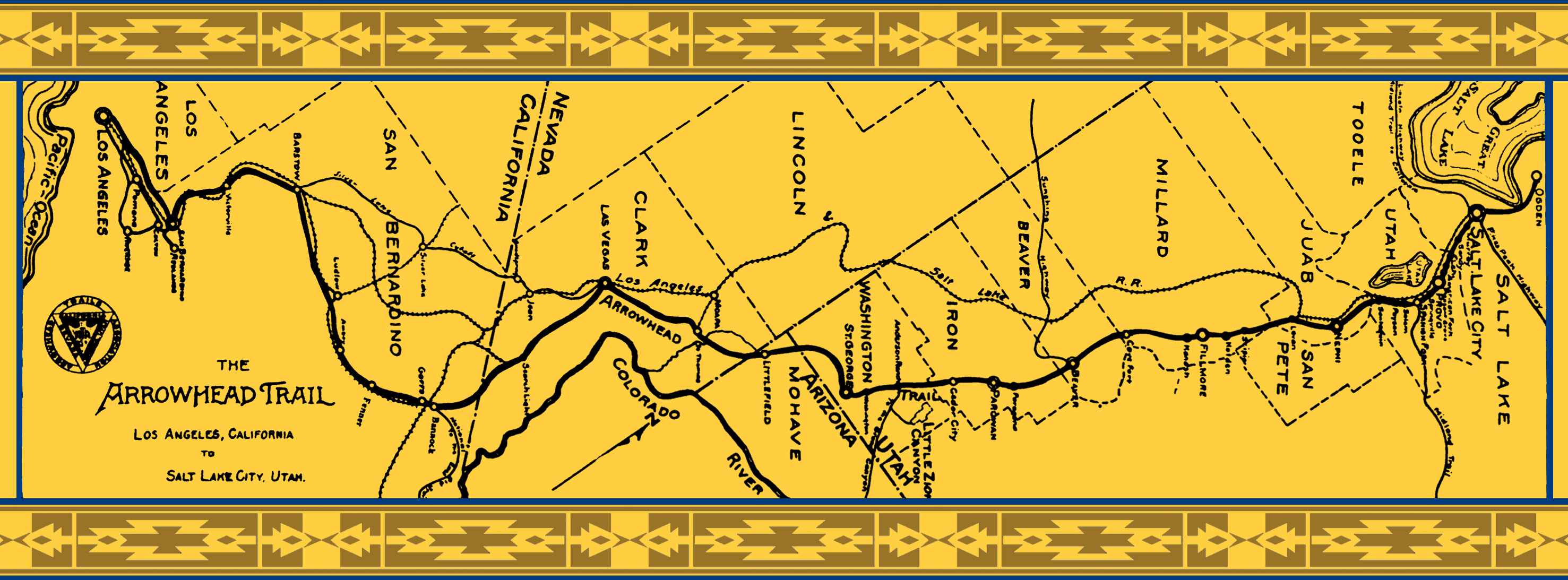
The main route of the Arrowhead Trail during the auto trails era followed the National Old Trails Road from Los Angeles to the junction near Bannock. It then went via Searchlight to Las Vegas, St. Thomas, and on to Mesquite, NV. A proposed alternate from Daggett through Silver Lake was suggested on maps in 1924, but the main route still appears on 1925 maps. With the establishment of US 91, a more direct route via Yermo and Baker to Las Vegas was created and appears in 1930s ACSC map booklets.
-
California
Los Angeles, San Bernardino, Victorville, Barstow,
Route by ca. 1916: Ludlow, Amboy, Fenner, Goffs, Bannock.
Silver Lake alternate ca. 1924: Daggett, Coyote Well, Silver Lake, Francis Spring.Nevada
Route by ca. 1916: Searchlight, Las Vegas, St. Thomas, Bunkerville, Mesquite.
Silver Lake alternate ca. 1924: Sandy Mill, Good Springs, Jean, Sutor, Las Vegas, Griffith Summit, St. Thomas, Bunkerville, Mesquite.Arizona
Littlefield.
Utah
St. George, Washington, Andersons Ranch, Cedar City, Parowan, Paragonah, Beaver, Cove Fort, Kanosh, Fillmore, Holden, Scipio, Levan, Nephi, Santaquin, Payson, Salem, Spanish Fork, Springville, Provo, American Fork, Lehi, Sandy, Murray, Salt Lake City.
Sources
- Church, Lisa Michele. Red Rocks and Race Cars: Charles Bigelow and the Arrowhead Highway. St. George, Utah: Washington County Utah Historical Society, Sept 27, 2018.
- Lyman, Edward Leo. "The Arrowhead Trails Highway: The beginning of Utah's other route to the Pacific Coast". Utah Historical Quarterly 67, no. 3 (Summer 1999), 242–264. Champaign, IL: University of Illinois Press.
- Rand McNally Official 1924 Auto Trails Map / California, Nevada [map]. Scale ca. 1:1,000,000. Chicago: Rand McNally, 1924.
- Rand McNally Auto Trails Map / District No. 15–16 (California, Nevada) [map]. Scale not given. In: Rand McNally Commercial Atlas of America. Fifty-fifth edition. Chicago: Rand McNally, 1924, pages 466–467.
Note: many of the auto trail maps in this atlas appear to predate 1924. - Rand McNally Official 1925 Auto Trails Map / Arizona, New Mexico [map]. Scale ca. 1:1,000,000. Chicago: Rand McNally, 1925.
- Rand McNally Junior Auto Trails Atlas of the United States. Scale not given. Chicago: Rand McNally, 1925.
Arrowhead Trail Contemporary Articles at AmericanRoads
- Plan Another Desert Race
― Reprinted from The Automobile, 27 July 1916, page 164. - A Visit to Little Zion Canyon: Utah’s Scenic Wonder
― Reprinted from American Motorist, 1 August 1916, page 7. - Arrowhead Trail Joins Lincoln Road
― Reprinted from Automobile Topics, 2 December 1916, page 378. - Easy Grades on Arrowhead Trail
― Reprinted from Motor Age, January 1917, page 102. - Arrowhead Trail From Los Angeles to Salt Lake
― Reprinted from Motor West, 15 September 1917, page 9. - Arrowhead Lamp Posts Mark the Arrowhead Trail
― Reprinted from Popular Science, December 1917, page 908.
Arrowhead Trail Links
Arrowhead Trail. St. George, Utah: Washington County Utah Historical Society. Accessed August 15, 2021.
Church, Lisa Michele. Red Rocks and Race Cars: Charles H. Bigelow and tourism development along the Arrowhead Highway [Presentation]. Presented to the Utah State History Conference. September 28, 2018.
Kohler, Richard R. Arrowhead Trail in St. George. St. George, Utah: Washington County Utah Historical Society, Nov 17, 2018.
Hall-Patton, Mark. "The road much traveled". Nevada Public Radio. June 1, 2014.