Menu
Albert Pike Highway

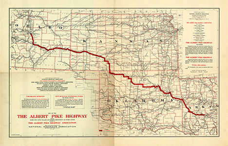
Map of the Albert Pike Highway, 1919. National Highways Association.
The Albert Pike Highway was named for American lawyer and author Albert Pike ![]() (1809–1891). Pike was a complex and controversial figure. He is most famous as a leader in Freemasonry, and wrote the primary text for the Scottish Rite's southern jurisdiction. He also served as an officer in the Mexican-American war and was a bigadier general in the Confederate army. Although as a lawyer he often defended native American tribes before the Supreme Court, and expressed his belief later in the evils of slavery, he was a racist who opposed the voting rights of blacks in America.
(1809–1891). Pike was a complex and controversial figure. He is most famous as a leader in Freemasonry, and wrote the primary text for the Scottish Rite's southern jurisdiction. He also served as an officer in the Mexican-American war and was a bigadier general in the Confederate army. Although as a lawyer he often defended native American tribes before the Supreme Court, and expressed his belief later in the evils of slavery, he was a racist who opposed the voting rights of blacks in America.
Association
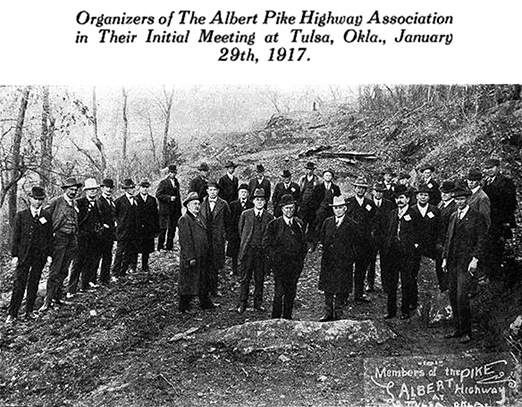
Orgnized: January 29, 1917. Tulsa, Oklahoma.
Headquarters: Tulsa, Oklahoma.
Officers, 1917: Cyrus S. Avery, president, Tulsa.
Officers, 1919: Cyrus S. Avery, president, Tulsa; E. Bee Guthrey, secretary, Tulsa; J. M. Berry, treasurer, Tulsa; G. A. Callahan, vice president, Hot Springs, OK [sic ?]; Chas. E. Thomas, vice president, Colorado Springs, CO; B. F. Arnold, vice president, Coldwater, KS; H. B. Bullen, vice president, Stillwater, OK.
Officers, 1921: Cyrus S. Avery, president, Tulsa; E. Bee Guthrey, secretary, Tulsa; J. M. Berry, treasurer, Tulsa.
Albert Pike Highway cities and towns by State
-
Arkansas
Hot Springs, Crystal Springs, Mount Ida, Buck Knob, Boles, Waldron, Hon, Mansfield, Huntington, Jenny Lind, Fort Smith.
-
Oklahoma
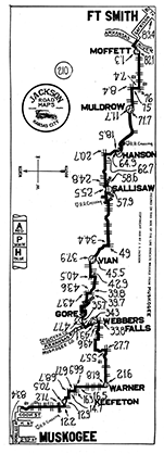
Moffett, Roland, Muldrow, Hanson, Sallisaw, Vian, Gore,
Early route ca. 1917–1919: Braggs, Fort Gibson,
Later route ca. 1920– : Webbers Falls, Warner, Keefeton,
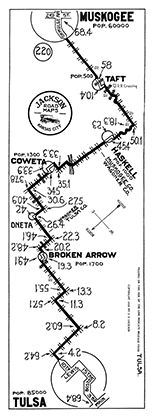
Muskogee, Taft, Haskell, Stonebluff, Leonard, Bixby, Tulsa, Sand Springs, Fisher, Keystone, Mannford, Oilton, Yale, Stillwater, Perry, Lucien, Hayward, Covington, Fairmont, Enid, Nash, Jet, Cherokee, Ingersoll, Alva, Cora, Lookout. -
Kansas
Coldwater, Greensburg*, Mullinville, Ford, Fort Dodge, Dodge City**, Cimarron, Ingalls, Charleston, Pierceville, Garden City, Holcomb, Deerfield, Lakin, Kendall, Syracuse, Medway, Coolidge.
*Early route may have gone via Bucklin.
**Concurrent with the National Old Trails Road between Dodge City and La Junta, CO. -
Colorado
Holly, Millwood, Granada, Grote (aka Carlton), Lamar, Hasty, Las Animas, La Junta, Swink, Rocky Ford, Manzanola, Fowler, Avondale, Vineland, Pueblo, Pinon, Buttes, Fountain, Colorado Springs.
Maps
Jackson Road Maps
Albert Pike Highway, Ft. Smith to Muskogee, 1920. (left)
Albert Pike Highway, Muskogee to Tulsa, 1920. (right)
Sources
- Map of the Albert Pike Highway : showing every city, town, village and hamlet throughout its entire length / proposed by the Albert Pike Highway Association [map]. Scale ca. 1:2,010,000. Washington, DC: National Highways Association, July 1919.
- Rand McNally Official 1923 Auto Trails Map / District No. 12 (Kansas, southern Nebraska, eastern Colorado, northeastern New Mexico, northern Oklahoma, northwest Texas) [map]. Scale ca. 1:1,311,000. Chicago: Rand McNally, 1923.
- Rand McNally Official 1923 Auto Trails Map / State of Colorado [map]. Scale not given. Chicago: Rand McNally, 1923.
- Rand McNally. Official Auto Trails Map of the United States featuring tourist campsites [map]. Scale ca. 1:4,693,000. Waterloo, Iowa: United States Touring Information Bureau, Inc., 1923. In: The Complete Camp Site Guide and Latest Highway Map of U.S.A. / Together with official directory of aeroplane landing fields. 1923 edition. Waterloo, Iowa: United States Touring Information Bureau, Inc., 1923, endpaper pocket.
- Rand McNally Auto Trails Map / District No. 12 (Kansas, southern Nebraska, eastern Colorado, northeastern New Mexico, northern Oklahoma) [map]. Scale not given. In: Rand McNally Commercial Atlas of America. Fifty-fifth edition. Chicago: Rand McNally, 1924, pages 372–373.
Note: many of the auto trail maps in this atlas appear to predate 1924. - Rand McNally Junior Auto Trails Map Colorado. Scale ca. 1:1,850,000. Chicago: Rand McNally, 1924.
- Rand McNally Junior Auto Trails Atlas of the United States. Scale not given. Chicago: Rand McNally, 1925.
Albert Pike Highway Links
Big road organizations meet in joint convention. In: The Nation's Highways, Volume I, number 2, May 1921, page 1.
The Albert Pike Highway in Wagoner County. In: The Nation's Highways, Volume I, number 6, September 1921, page 1.
The Albert Pike Highway bridge at Fort Smith, Arkansas In: The Nation's Highways, Volume I, number 8, November 1921, page 1.
Albert Pike improvements In: The Nation's Highways, Volume I, number 11, March 1922, page 3.
The Enid Convention. In: The Nation's Highways, Volume II, number 2, May 1922, page 1.
The Albert Pike, Woods County. In: The Nation's Highways, Volume II, number 3, June 1922, page 10.
The Albert Pike Highway in Oklahoma / Progress in Missouri / In Arkansas. In: The Nation's Highways, Volume II, number 11, March 1923, page 2.
Address by Cyrus Avery to the U.S. Highway 64 Association, Fort Smith, AR, 1930.


