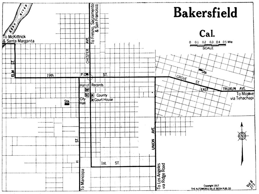
Click on map to enlarge to full size. Use back button to return.
Bakersfield, 1917
Click on map to enlarge to full size. Use back button to return.
Bakersfield, 1934, Official California State Division of Highways Map
Click on map to enlarge to full size. Use back button to return.
Bakersfield, 1944, Official California State Division of Highways Map
Click on map to enlarge to full size. Use back button to return.
Fresno, 1934, Official California State Division of Highways Map
Click on map to enlarge to full size. Use back button to return.
Fresno, 1944, Official California State Division of Highways Map
Click on map to enlarge to full size. Use back button to return.
Los Angeles, 1917
Click on map to enlarge to full size. Use back button to return.
Los Angeles, 1934, Official California State Division of Highways Map
Click on map to enlarge to full size. Use back button to return.
Los Angeles, 1944, Official California State Division of Highways Map
Click on map to enlarge to full size. Use back button to return.
Merced, 1917
Click on map to enlarge to full size. Use back button to return.
Modesto, 1917
Click on map to enlarge to full size. Use back button to return.
Monterey, 1917
Click on map to enlarge to full size. Use back button to return.
Oakland, 1917
Click on map to enlarge to full size. Use back button to return.
Pasadena, 1917
Click on map to enlarge to full size. Use back button to return.
Redding, 1917
Click on map to enlarge to full size. Use back button to return.
Sacramento, 1917
Click on map to enlarge to full size. Use back button to return.
Sacramento, 1934, Official California State Division of Highways Map
Click on map to enlarge to full size. Use back button to return.
Sacramento, 1944, Official California State Division of Highways Map
Click on map to enlarge to full size. Use back button to return.
San Bernardino, 1917
Click on map to enlarge to full size. Use back button to return.
San Bernardino, 1934, Official California State Division of Highways Map
Click on map to enlarge to full size. Use back button to return.
San Diego, 1917
Click on map to enlarge to full size. Use back button to return.
San Diego, 1925
Click on map to enlarge to full size. Use back button to return.
San Diego, 1928
Click on map to enlarge to full size. Use back button to return.
San Diego, 1933
Click on map to enlarge to full size. Use back button to return.
San Diego, 1934, Official California State Division of Highways Map
Click on map to enlarge to full size. Use back button to return.
San Diego, 1934
Click on map to enlarge to full size. Use back button to return.
San Diego, 1934
Click on map to enlarge to full size. Use back button to return.
San Diego, 1940
Click on map to enlarge to full size. Use back button to return.
San Diego, 1944, Official California State Division of Highways Map
Click on map to enlarge to full size. Use back button to return.
San Francisco, 1934, Official California State Division of Highways Map
Click on map to enlarge to full size. Use back button to return.
San Jose, 1917
Click on map to enlarge to full size. Use back button to return.
San Jose, 1934, Official California State Division of Highways Map
Click on map to enlarge to full size. Use back button to return.
San Jose, 1944, Official California State Division of Highways Map
Click on map to enlarge to full size. Use back button to return.
Santa Barbara, 1944, Official California State Division of Highways Map
Click on map to enlarge to full size. Use back button to return.
Santa Clara, 1934, Official California State Division of Highways Map
Click on map to enlarge to full size. Use back button to return.
Santa Clara, 1944, Official California State Division of Highways Map
Click on map to enlarge to full size. Use back button to return.
Santa Cruz, 1917
Click on map to enlarge to full size. Use back button to return.
Santa Rosa, 1917
Click on map to enlarge to full size. Use back button to return.
Stockton, 1934, Official California State Division of Highways Map
Click on map to enlarge to full size. Use back button to return.
Stockton, 1944, Official California State Division of Highways Map
Click on map to enlarge to full size. Use back button to return.